


(TheNewswire)
 | |||||||||
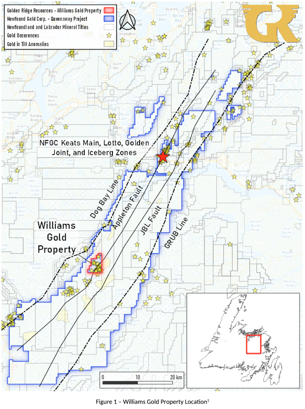
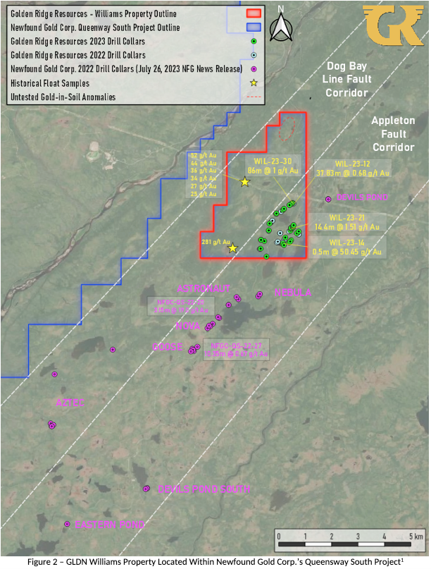
Kelowna, British Columbia - TheNewswire - November 30, 2023 - Golden Ridge Resources Ltd. (“Golden Ridge” or “the Company”) (TSXV:GLDN) is pleased to announce the completion of the 2023 Phase II drilling campaign at the Williams Gold Property (“Williams” or “the Property”) within the Appleton and Dog Bay Fault Corridors (Figure 1). Golden Ridge intersected in the first hole of the 2022 Phase II drilling campaign the largest gram meter intercept of 86 meters of 1.00 g/t Au on the Williams Property to date. The Property is surrounded by New Found Gold Corp (NFGC)’s Queensway Gold Property where NFGC is currently undertaking a 500,000 meter drill program (Figure 2).1
Highlights
-
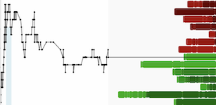
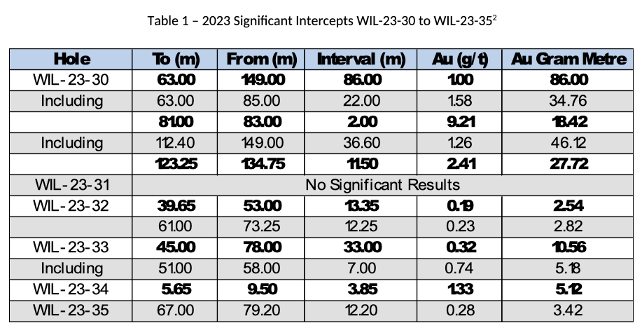
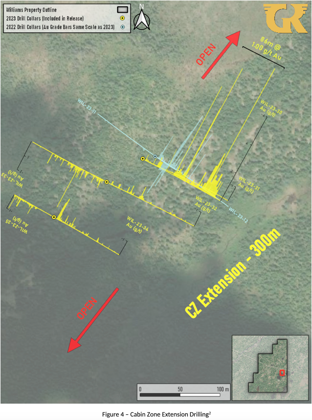
WIL-23-30 intersected 86 meters of 1.00 g/t Au from 63.00 meters; including 2.00 meters of 9.21 g/t Au from 81.00 meters (Table 1)
-
Drilling focused on building off 2022 results and tested new prospective target areas.
-
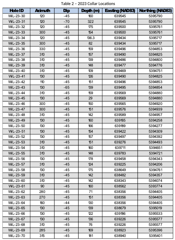
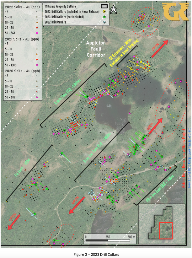
41 holes were drilled for a total of 5,982 meters in the 2023 campaign (Figure 3)
-
Mineralization was noted to be more pervasive and widespread than encountered in Phase I Drilling
“Drilling 86 gram-meters Au in our first reported hole of Phase II drilling is very exciting. The highlighted intercept in WIL-23-30 represents our highest gram-meter interval to date at Williams. Drilling has now confirmed at least five distinct mineralized zones at Williams all of which remain open along strike and at depth”, stated Mike Blady, Director, CEO and President of Golden Ridge. “Observing the increased alteration and veining drilled over 41 holes in Phase II strongly suggests that we are vectoring towards the full potential of the Property.”
Phase II drilling was initially focused on WIL-22-12, which intersected a complex system of veins and veinlets grading 37.93 meters grading at 0.68 g/t Au. First identified during the 2022 maiden drilling program this area is now known as the Cabin Zone Extension (CZE) and represents the northeastern extension of a 1-kilometer-long gold-in-soil anomaly known as the ‘Cabin Zone’ (Figure 4). In total, 6 drillholes WIL-23-30 through WIL-23-35 (totalling 1,029 meters) were drilled at the Cabin Zone Extension. All drill holes were successful in intersecting a broad alteration halo and associated system of vein and veinlets first observed in Phase I drilling. Broad mineralization is exemplified by WIL-23-30 (a 12.5-meter step-out from WIL-22-12) intersecting an 86-meter section grading 1 g/t gold including a 2-meter section which yielded 9.21 g/t. Drilling at the Cabin Zone Extension also identified several fault/rubble zones throughout often associated with graphite. The fault/rubble zones locally contain vein fragments which indicate syn-mineralization to post-mineralization movement along these structures. Mineralization at the Cabin Zone Extension is open along strike and down dip and further drilling will be required to further delineate the nature of gold mineralization.
Click Image To View Full Size
Williams Gold Property 2023 Drill Program
Forty-one holes were drilled in the Phase II diamond drill program consisting of 5,982 meters. Golden Ridge has now completed 70 holes for 10,182 meters of drilling over Phase I and II programs. The balance of assay results from the 2023 program have yet to be received. Drill holes were predominantly in the 100m to 200m range focusing on testing soil, bedrock, and drilling anomalies previously identified by earlier exploration programs. Highlights of the previous field programs completed by Golden Ridge Resources from 2020 - 2022 include float samples assaying up to 281 g/t Au and soil samples up to 1,503 ppb Au.
Mineralization in Phase II was broader in nature consisting of a complex system of vein, veinlets, and vein breccia, up to 1.5-meters in size. Gold-bearing veins are often associated with weak to locally intense sericitic and chloritic alteration. Additionally, sulphide mineralization appears to be more pervasive in core obtained from Phase II drillholes. The host rock often contains disseminated pyrite crystals, blebs, and stringers throughout and acicular crystals and blebs of arsenopyrite near mineralized zones. Trace pyrrhotite has also been observed in the host rock but this is commonly restricted to areas of intense veining. Gold-bearing veins contain primarily pyrite and are often associated with arsenopyrite, pyrrhotite, chalcopyrite, and galena with trace amounts of stibnite, molybdenite and sphalerite. Golden Ridge has noted that the most reliable pathfinder for the presence of high-grade gold is increasing concentrations of arsenopyrite.
Golden Ridge is continuing to model the structural controls of the transportation and deposition of gold bearing fluids on the Williams Property. Vein systems suggest the presence of both brittle and ductile features indicating a transitionary tectonic environment. Fracture filling appears to be the most prevalent style of vein deposition representing a trans-tensional environment. The presence of sigma clasts, gouge in faults, and folding in quartz veins are indicative of a more ductile environment. Vein systems associated with sericitic-chloritic alteration and arsenopyrite are often used to distinguish gold-bearing veins from other generations of quartz veins observed throughout the Property.
Click Image To View Full Size
Click Image To View Full Size
Click Image To View Full Size
Click Image To View Full Size
Sampling & Laboratory Methodology:
True widths of the report intersections have not been calculated at this time. Drilling was primarily conducted in NQ. Samples were marked and QAQC by Golden Ridge staff. Drill core was split using a diamond core cutting saw and sealed in polybags.
Samples were sent to the Mobile Sample Preparation Unit (MSPU) of SGS Canada Inc. (SGS) in Grand Falls, Newfoundland for sample preparation, and then to the laboratory of SGS Canada Inc. in Burnaby, British Columbia for fire assay. SGS is ISO/IEC 17025 accredited. Samples were analyzed for gold by fire assay using a 30g charge (ICP-AES). Samples containing visible gold or greater than 1 g/t Au in fire assay were also assayed using the metallic screen method. Golden Ridge submits certified reference standards and blanks at a rate of approximately 5% of the sample total.
Qualified Person:
Dr. Stephen Amor, PhD, PGeo, technical advisor to the Company, is the Qualified Person as defined by National Instrument 43-101 who has reviewed and approved the technical data in this news release.
Acknowledgments:
Golden Ridge Resources acknowledges the financial support of the Junior Exploration Assistance Program, Department of Industry, Energy, and Technology, Government of Newfoundland and Labrador.
About Golden Ridge Resources:
Golden Ridge is a TSX-V listed exploration company engaged in acquiring and advancing mineral properties located in Newfoundland and British Columbia. Golden Ridge is currently focused on exploration and development of the Williams Gold Property located in the Central Newfoundland Gold Belt. The Company owns a 100% interest in the 1,700-hectare Hank copper-gold-silver-lead-zinc property which is currently under option to King Fisher Metals Corporation and the 3,000-hectare Hickman copper-gold property located in the Golden Triangle district, approximately 140 kilometres north of Stewart, British Columbia.
Golden Ridge Resources Ltd.
Mike Blady
Chief Executive Officer
Tel: (250) 717-3151
Website: www.goldenridgeresources.com
Cautionary Note Regarding Forward-Looking Statements
Certain statements contained in this news release, constitute "forward-looking information" as such term is used in applicable Canadian securities laws. Forward-looking information is based on plans, expectations and estimates of management at the date the information is provided and is subject to certain factors and assumptions, including: that the Company's financial condition and development plans do not change as a result of unforeseen events, that the Company obtains required regulatory approvals, that the Company continues to maintain a good relationship with the local project communities. Forward-looking information is subject to a variety of risks and uncertainties and other factors that could cause plans, estimates and actual results to vary materially from those projected in such forward-looking information. Factors that could cause the forward-looking information in this news release to change or to be inaccurate include, but are not limited to, the risk that any of the assumptions referred to prove not to be valid or reliable, which could result in delays, or cessation in planned work, that the Company's financial condition and development plans change, delays in regulatory approval, risks associated with the interpretation of data, the geology, grade and continuity of mineral deposits, the possibility that results will not be consistent with the Company's expectations, as well as the other risks and uncertainties applicable to mineral exploration and development activities and to the Company as set forth in the Company's Management’s Discussion and Analysis reports filed under the Company's profile at www.sedar.com. There can be no assurance that any forward-looking information will prove to be accurate, as actual results and future events could differ materially from those anticipated in such statements. Accordingly, the reader should not place any undue reliance on forward-looking information or statements. The Company undertakes no obligation to update forward-looking information or statements, other than as required by applicable law.
Neither the TSX Venture Exchange nor its Regulation Services Provider (as that term is defined in the policies of the TSX Venture Exchange) accepts responsibility for the adequacy or accuracy of this release.
1This news release contains information about adjacent properties on which Golden Ridge has no right to explore or mine. Readers are cautioned that mineral deposits on adjacent properties are not indicative of mineral deposits on the Company’s properties
2The intervals reported in these tables represent drilling intersects and insufficient data is available at this time to state true thickness of the mineralized intervals.
Copyright (c) 2023 TheNewswire - All rights reserved.

